


I didn't want to spoil to surprise by blogging about it, so I had to keep all of you in the dark on my plans too. :)
I am home for a few weeks in order to facilitate a household relocation up to Delaware. After getting us moved and settled-in a little bit, I'll head back to the trail. It sounds like at least Wrong Turn (a hiker I know from Southern California) will be right there when I get back, so perhaps I'll have a mini reunion!
[ view entry ] ( 6673 views ) | permalink | print article
[ view entry ] ( 2840 views ) | permalink | print article
If you're keeping count, I hike 702 miles in Southern California, jumped to Truckee, CA, and as of this moment I have hiked 350 miles from there! That's 1050 miles! Cha-ching!
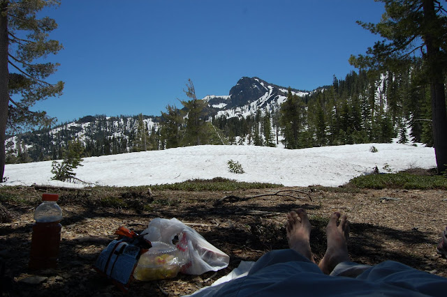
The last few days have been trying. For about 3 miles I had patchy snow and hillsides gushing with water, followed by a 5-6 mile ridge walk completely covered in snow. GPS came in handy again, and the crampons were adorned to help with some tricky side-slopes. After the snow, the sun and the trail really heated up. The volcanic rock soaks up the heat of a full sun and radiates it back - baking me from the top and the bottom. The foliage was lush with green ferns, poison oak, and a dozen new plants - creating a virtual sauna that was difficult to breath at times (I don't do well in high humidity).
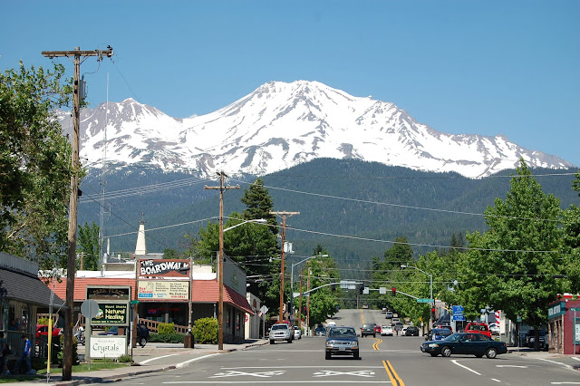
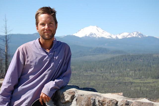
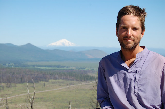
Mount Shasta, the city, sits beneath Mount Shasta, the mountain. It's a giant, beast of a mountain looming over the town and still covered in snow. I think the spirit of the mountain manifests itself in the local grocery store deli counter where I just had the most delicious wrap I have ever had. Yes, Andrea, possibly better than that wrap we had in Hawaii. Maybe the high elevation (or hunger) enhances my taste buds, cuz I swear this is the best white hot chocolate I've had too. Hrm, maybe I should give mushrooms another try while I'm here.
Anyway, I've been crossing paths with more hikers lately (one outside Lassen, two outside of Burney) so it's starting to get crowded. :)
[ view entry ] ( 6345 views ) | permalink | print article
It's so strange to me that everything in the title of this post can be experienced in only 4 days of hiking in Northern California.
A few miles before Belden Town, in between stretches of snow, I rounded a corner and found the large butt end of a brown bear pointing my way. 100' away it sat, contentedly eating some vegetation. I backed up, around the corner, picked up branches and started breaking them against the ground while singing loudly. It's head perked up and instantly it sprinted up the hill, away from me. Later i would curse myself for not pulling out my camera first. :(
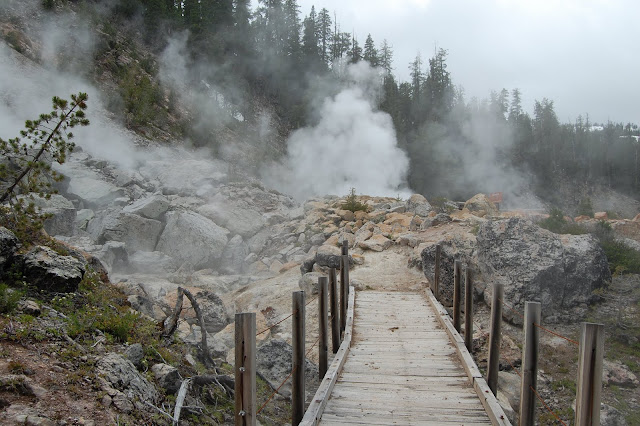
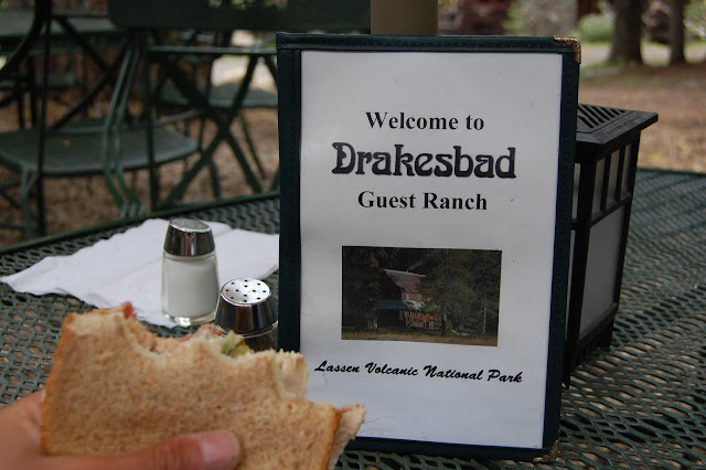
Three days later i was arriving at Drakesbad Guest Ranch inside Lassen Volcanic National Park. The first northbounder to reach Lassen (don't forget, i skipped the Sierra's). The day i arrived was full of cold rain, so unfortunately i did not take a picture of Boiling Lake - the world's most acidic lake. It was steaming so much that it resembled a giant pot of soup. At the ranch i would take a day off to soak in the hot spring-fed pool and day-hike up to Devil's Kitchen - a series of steaming hot springs, mud pots, and bubbling/steaming vents.
When i arrived at Drakesbad i spotted two familiar faces. Pyrite and Chinchilla, who i had last seen in Agua Dulce (mile 450) were there for their annual family reunion! They hiked the Sierra's to Toulumne Meadows and then drove up to Drakesbad. It was great seeing them again.
The western side of the park was still plowing out 15' of snow and was hoping that by July 8 they would be all plowed out. The trail, on the eastern side, had 0-5' of snow and wasnt too hard to navigate (without GPS). I was pleased when the snow ended and i had miles of high elevation meadows and flats to walk through.
It turns out that those meadows/flats would mark the start of a roughly 80 mile stretch with no snow! For two days i would walk on a high desert ridge/plateau and see snow-covered Mt Shasta to my north, and snow-covered Lassen Peak to my south. Each standing out starkly from the land around them. I was not expecting to find high desert again, especially one sitting on top of old lava flows.
From Old Station, through Burney, and nearing Castilla (highway 5) i won't have snow to think about. For maybe 15-20 miles, a day before Castilla, i will hit it again. But snow, like most things, is just annoying and not anything i need to worry about. My feet will be wet for 20 miles, my pace slowed a little, but NO MOSQUITOES! Yay!
Next stop Mt Shasta, CA!
[ view entry ] ( 4897 views ) | permalink | print article
Here is my snow report for Truckee to Burney.
I am currently in Burney, CA, having started in Truckee on June 21.
1. Basically, going in to town or a highway crossing you will see the trail.
2. Between towns/highways i had lots of snow. Above 6300 i rarely saw the trail, above 5800 i would easily lose it with the patchy snow, below 5800 would be small patches or pure, dry land.
3. Conditions may vary depending on location and sun exposure. Streams for me were mostly snow bridges, but by now there might be some exposed.
4. GPS a must. Even following fire roads was difficult with drifts of +/- 6' obscuring the topography.
5. Crampons/traction? Not sure. I wore crampons for the first 30 miles from Truckee because temps were still cold, but beyond that i rarely ever NEEDED them. The surface snow was loose enough most of the time so that a good kick-step was sufficient. I never wished i had an ice axe. The day after Lassen got that rain, i almost needed traction since the snow packed up hard.
6. I'm able to do 22-28 miles on snow, which is down from my usual 32-36 on dry land. Definitely eating/drinking twice my normal diet.
7. Truckee to Belden i saw NO other people on the trail (except one trail crew near Sierra City) when i ran into Gourmet + Obsidian who were turning back. I rarely ever saw tracks, but i did often see vehicle tracks. Oh, and somehow the bear/deer still know where the PCT is under all that snow.
8. The only difficult stream crossing was Kings Creek 2.5 miles north of Drakesbad. The bridge is washed out (happens every year) but there is a very slick tree across the creek. In the morning there was 8" of clearance under the tree when i shimmied across, but at least 4 sobo hikers have been swept away here, all having crossed in the evening. It can be 4-5' deep, so plan ahead.
9. The creek crossings north of Belden Town, at the top of the long canyon, were fine. One had a nice long, shallow crossing (knee to thigh deep depending on time of day), the second crossing has a big fallen tree to use.
[ view entry ] ( 7896 views ) | permalink | print article
<<First <Back | 1 | 2 | 3 | 4 | 5 | 6 | 7 | 8 | 9 | Next> Last>>